태풍 마이삭북상 대비해야한다.
안녕하세요. 달빛의 꽃입니다.
태풍 마이삭 북상 우리는 대비해야합니다.
제 9호 태풍 마이삭은 오는 3일 새벽부산 인근에 상륙하빈다.
마이삭은 역대 두 번째로 많은 재산 피해를 발생시킨 2003년 태풍 매미와 비슷한 경로로 오고 있으며 직전의 제 8호 태풍인 바비보다도강할 전망입니다.
마이삭이 우리나라에 상륙하면 최대 400mm의 매우 많은 비와 최대 순간풍속 시속 180km에 달하는 매우 강한 바람이 불것으로 예상됩니다.
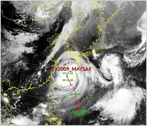
기상청은 마이삭이 1일 오후 3시기준 일본 오키나와 서북서쪽 약 220km 부근 해상에서 시속 16km 의 속도로 북북동진 중이라고 밝혔습니다.
태풍의 중심기압은 935hpa,강풍반경은 380km,최대풍속은 매우 강한 수준인 초속 49m입니다.
마이삭은 오는 2일 제주도에 가장 가까워지고 3일 새벽 경남 남해안에 상륙해 부산 ,울산,경주등 영남지역
도시들을 관통한 뒤 같은날 오후 6~9시께 동해상으로 빠져나갈 것으로 분석됩니다.
기상청 우진규 예보분석관은 마이삭은 3일 오전3시께 경남 해안 부근에 상륙할 가능성이 가장크다며 구체적인 지점은 거제와 부산사이정도로 예측하나 북상 과정에서 주변 환경에 따라 달라질 수 있다고 설명했습니다.
마이삭의 예상 이동경로와 비슷한 태풍으로는 2003년 매미가 있습니다.
매미는 2003년 9월 12일 당시의 최대 순간풍속이 역대 가장 빠른 초속 60.0m에 달했습니다.
당시 매미는 거대한 철제 크레안을 쓰러뜨리는 등 2002년 태풍 루사 다음으로 많은 재산상의 피해를 낳았습니다.
예보분석관은 현재 이동경로가 매미와 유사하긴하나 어디에 상륙하느냐에 따라 양상이 많이 다라진다며 피해 규모를 예측하긴 어렵지만 마이삭의 영향으로 강한 바람이 불고 많은 비가 내림에 따라 심각한 피해가 발생할 가능성이 있다고 우려했습니다.
지난달 발생한 태풍 바비가 비보다는 바람이 더 위험했다면 마이삭은 매우 강한 비와 바람을 모두 동반하는 것이 특징입니다.
바람의 강도가 비슷한 수준이어도 바비보다 마이삭이 우리나라에 더 큰피해를 줄 수 있습니다.
태풍으로 인한 예상 강수량은 강원 영도,경북 동해안 ,경남 전라 동부,제주도,울릉도,독도 100~300mm입니다.

특히 강원 동해안 ,경상 동해안 ,제주도 산지에서는 400mm가 넘는 비가 쏟아질 수 있습니다.
서울 ,경기도와 강원 영서 ,축복,경북(동해안 제외)은 100~200mm,충남 ,전라도(전라 동부 제외) 서해5도는 50~150mm의 비가 올 전망입니다.
예상 초대순간풍속은 제주도와 경상 해안 시속 108~180km(초속 30~50m),강원 영동,남부지방(경상 해안과 전북 서부 제외)72~144km(20~40m), 그 밖의 지방 36~108km(10~30m)입니다.
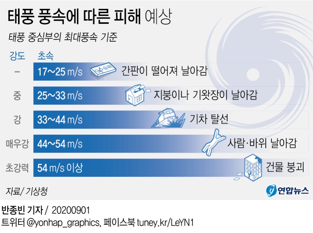
예보분석관은 풍속이 초속 40m이상이면 사람이 서 있기 힘들 정도라며 가건물이나 약한 구조물은 지붕이 바람에 날려갈 수 있고 거리에 있는 신호등이나 가로수는 파손 가능성이 있다고 설명했습니다.
이날 밤부터 3일사이전 해상에는 매우 강한 바람이 불고 매우 높은 물결이 일어 선박이나 양식장등 해상 시설물에 피해가 있으니 사전점검 을 철저히 하고 선박은 안전한곳으로 피항해야합니다.
특히 해안지역은 침수피해등 안전사고에 각별히 유의할 경우가있습니다.
오는 7일 천문조(달이나 태양과 같은 천체의 인력에 의하여 일어나는 조석)에 의해 바닷물 높이가 높은 기간이고, 태풍이 차차 접근하면서기상조(기상의 영향으로 바닷물이 밀려들거나 밀려 나가는 현상)와 높은 파고가 더해질것으로 보입니다.
따라서 2~3일 남해안과 동해안 ,제주도 해안에서는 폭풍해일이 일고 방파젷나 해안도로로 파도가 범람할 구 있는 만큼 사고 가능성에 대비해야합니다.
다만 태풍의 위치가 아직 우리나라 와 멀리 떨어져 있고 주변 기압계가 매우 유동적이어서 태풍의 이동속도,강도,이동경로는 다소 변경될 수 있습니다.
그러나 태풍의 강도가 거세진 만큼 경로 변동등에 다른 영향력 차이는 크지 않은 전망입니다.
태풍의 영향으로 2일은 전국이 흐리고비가 내릴 예정입니다. 또 강한 바람으로 인해 낮 기온은 전날보다 1~3도 낮은 24~31도로 예상됩니다.
We have to prepare for Typhoon Maisak.
Hello, I'm the flower of moonlight.
Typhoon Maisak north. We have to be prepared.
The ninth typhoon, Maisak, will land near Busan early Thursday morning.
Mysak is coming in a similar route to the 2003 Typhoon Maemi, which caused the second-largest property damage ever, and is expected to be stronger than the previous eighth typhoon, Bobby.
When Mysak lands in Korea, it is expected that there will be a lot of rain of up to 400mm and a very strong wind of up to 180km/h in the instantaneous wind speed.
The Korea Meteorological Administration (KMA) says Maisak is moving northward at a speed of 16 kilometers per hour from the sea about 220 kilometers northwest of Okinawa, Japan, at 3 p.m. on the 1st.
The center pressure of the typhoon is 935 hpa, the strong wind radius is 380 km, and the maximum wind speed is very strong at 49 m/s.
Maysak most closer in Jeju Island is two days, Namhae-gun, Gyeongsangnam-do, Korea in the morning the south coast three days through Gyeongsang Province, where cities such as race, Busan, Ulsan, Korea and the same day, or 9 a.m. to 6 p.m.East to veer off to.
Woo Jin-kyu, a weather analyst at the Korea Meteorological Administration, said, "Mysak is most likely to land near the coast of South Gyeongsang Province around 3 a.m. on the 3rd," adding, "The specific point is expected to be between Geoje and Busan, but it may vary depending on the surrounding environment in the process of moving northward."
There is a cicada in 2003 that is similar to Mysak's expected route.
On September 12, 2003, the maximum instantaneous wind speed reached 60.0 meters per second, the fastest ever.
At that time, cicadas suffered a lot of property damage after Typhoon Rusa in 2002, including the collapse of a huge iron Crean.
The forecast analyst said the current route is similar to the cicada, but it is difficult to predict the extent of the damage depending on where it lands, but he is concerned about the possibility of serious damage caused by strong winds and heavy rain due to Maisac's influence.
If last month's typhoon Bobby was more dangerous than rain, Maisac is characterized by both very strong rain and wind.
Even if the strength of the wind is similar, MySack can cause more damage to our country than Bobby.
Precipitation is expected by a typhoon Yeong Island, Jeju Island coast, Jeju Island, Jeju Island, Ulleung Island and eastern Gangwon-do, Korea Dokdo between 100 and 300 mm.
East Sea Coast, East Sea coast, Gangwon-do, Korea, Jeju Island production, in particular, it can rain more than 400 mm.
Seoul, Gyeonggi Province and Gangwon, a blessing, Cholla provinces, Cholla provinces (other than the eastern province), Chungcheongnam-do, Korea, between 100 and 200 mm The islands are 50 to 150 mm of rainfall expected.
The expected super instantaneous wind speed is 108-180km per hour (30 to 50m per second) on Jeju Island and the Gyeongsang coast, Yeongdong, Gangwon Province, and southern regions (excluding the Gyeongsang coast and western North Jeolla Province) 72 to 144km (20 to 40m) and 36 to 108km (10 to 30m) in other provinces.
The forecast analyst explained that if the wind speed is over 40 meters per second, it is hard for people to stand, and that for temporary buildings or weak structures, roofs can be blown away by the wind, and traffic lights or street trees on the streets are likely to be damaged.
Between this night and three days before that night, very strong winds and very high waves caused damage to marine facilities such as ships and fish farms, so we must thoroughly inspect the ship in advance and evacuate the ship to a place.
Especially in coastal areas, special attention may be paid to safety accidents such as flood damage.
It will be a period of high sea water levels due to astronomical tides (birds caused by celestial forces such as the moon and the sun) on the 7th, and weather conditions (the phenomenon of seawater rushing in or out due to weather effects) and high waves will be added as the typhoon approaches.
As a result, two or three days the south coast and coastal storm surge in the East Sea coast, Jeju Island is bangpajenna The waves inundated by the coastal road to be old, as must prepare for possible accidents.
However, since the location of the typhoon is still far from Korea and the surrounding barometer is very flexible, the speed, intensity, and path of movement of the typhoon can be changed somewhat.
However, as the intensity of the typhoon has increased, the difference in other influences, such as the change in route, is not likely to be significant.
Due to the influence of the typhoon, the whole country will be cloudy and rainy on the 2nd. Due to strong winds, daytime temperatures are expected to be between 24 and 31 degrees Celsius, 1 to 3 degrees lower than the previous day.
www.youtube.com/watch?v=Lv7iQ27bh-c
https://www.youtube.com/watch?v=bRhTZ4kP6sc


댓글